Problem setting
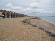
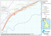
Pevensey Bay sea defences consist of a 9 km long shingle
(gravel) barrier beach between Eastbourne and Bexhill in
East Sussex, on the English Channel coast of southern England
(See map).
Many properties have been constructed on the crest of the
shingle bank. Immediately inland there is the Pevensey Levels,
an area of about 50 km2, which would be flooded at high
spring tide if the sea defence becomes breached. The Pevensey
Levels themselves are an area of low-lying marshland prized
for its high conservation and agricultural value. This area
also contains over 10,000 properties, plus caravan parks,
roads and a rail link.
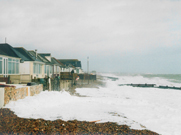
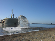
Barrier beaches can be overtopped by large
waves, may leak or roll-back landward, and ultimately may
breach (Technical
Report Understanding barrier beaches, Defra). All of
these events give rise to a risk of flooding, and temporary
flooding events did occur at Pevensey in 1926, 1935, 1965
and 1999. The volume of mobile beach material leaving the
barrier beach at its eastern end is greater than volume
of mobile beach material naturally reaching the frontage
at the south-west. The natural response of the barrier beach
would be roll-back of shingle ridge and re-alignment to
form a swash-aligned bay beach. This natural response is
prevented by:
 |
Blockage of the coarse sediment
supply by the construction of groynes and breakwaters,
including the construction of Sovereign Harbour marina
in 1992; |
 |
|
Construction of approximately 150 groynes
between Eastbourne and Bexhill in three main phases
from 1870; |
 |
|
Nourishment of the barrier beach by adding
fresh gravel from offshore; |
 |
|
Recycling gravel from parts of the beach
with more than enough gravel to areas that are lacking;
and |
 |
|
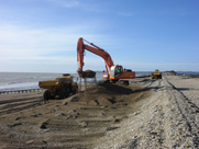
Reprofiling the barrier beach using diggers
to push shingle back up to the barrier’s crest; |
 |
The problem at Pevensey is how to manage
the barrier beach within the context of the UK developing
strategy of flood and coastal erosion risk management (Defra,
Making Space for Water Homepage)
Description of the coastline
The western limit of the shoreline considered here is Beachy
Head, the moderately resistant chalk cliff that forms the
western end of the sediment sub-cell 4c for beach sand and
the western limit of the local South Foreland to Beachy
Head Shoreline
Management Plan (SMP). This is not a closed boundary
for sediment and the beaches of Eastbourne have traditionally
relied on a supply of gravel from the west, passing round
Beachy Head. However, the construction of man-made structures
has reduced the supply of beach-grade sediment from the
west. Sediment is also provided by the erosion of the shore
platform and cliffs.
In 1992 Sovereign Harbour marina, was dredged out of the
accumulation of shingle that formed a cupate foreland known
as the Crumbles and as Langley Point on the eastern side
of Eastbourne. The Crumbles is believed to have developed
through the onshore migration of a gravel bar between 1100
AD and 1600 AD. Longshore drift then moved gravel north-eastwards
along the coastline. This loss of sediment caused the shoreline
to retreat by around 1m/year, although erosion has been
largely halted by the building of groynes from 1884. Today,
gravel accumulates on the western side of the harbour and
erosion occurs on the eastern side, caused by the harbour.
This area is believed not to receive a supply of gravel
from offshore sources any more.
Pevensey and Norman’s Bay are areas of low-lying
land (Hooe Level and Pevensey Level) fronted by a continuous
gravel barrier beach. Pevensey Levels used to be a tidal
inlet, where in 1066 William the [Norman] Conqueror landed
at a site now over 1km inland (marked Castle at Pevensey
on map). Wave-driven nett sediment transport on the beach
is from west to east and this eventually closed the inlet.
This shoreline becomes increasingly exposed to wave attack
towards the east as the shelter from Beachy Head and Sovereign
Harbour diminishes. Groynes were first constructed at the
western end of this frontage in1907, with groynes added
at Pevensey Bay between 1952 and 1962 and at Norman’s
Bay between 1962 and 1967. Many of these groynes are in
a poor state of repair.
The eastern limit of the shoreline considered here is Cooden
Cliffs at Bexhill, which lie to the East of Hooe levels
and consist of cretaceous thin shale, clay and sandstone.
The foreshore is a mix of shingle and sand, which overlies
an occasionally exposed shore platform of Tunbridge Wells
silts and sandstones. Analysis of historic Ordnance Survey
maps shows the cliffs experienced erosion between 1982 and
1950. The cliffs are now largely defended, but the foreshore
is undergoing erosion, which will, in time, undermine the
cliff defences.
Present day management approach
The shoreline management policies considered within the
SMP (www.se-coastalgroup.org.uk)
were those defined by Defra:
- Hold the line: maintain or upgrade the level of protection
provided by defences.
- Advance the line: build new defences seaward of the
existing defence line.
- Managed realignment: allowing retreat of the shoreline,
with management to control or limit movement.
- No active intervention: a decision not to invest in
providing or maintaining defences.
The present day policy is to hold the line, which is implemented
by Pevensey Coastal Defence Limited (www.pevensey-bay.co.uk)
in the following way:
- removal of about 140 relect groynes, leaving only 10
groynes at locations with a significant change in beach
orientation;
- periodic renourishment of the beach using shingle imported
from an offshore dredge site (Owers Bank);
- bypassing shingle round Sovereign Harbour to the main
beach;
- recycling shingle to depleted areas (generally involving
movement of shingle in lorries along the beach from east
to west as net transport is from west to east);
- re-profiling of beach to push shingle back towards
the ridge crest.
Application of the Frame of Reference approach
The Frame
of reference approach provides a systematic framework
for the development and implementation of a policy for coastal
management. The application of the Frame of Reference to
Pevensey is illustrated in the figure below and contains
the following elements:
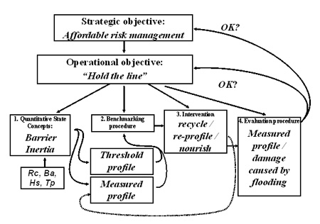
Strategic Objective
The UK has adopted a Flood and Coastal Erosion Risk Management
Approach, whereby the coasts
and benefits of each proposed scheme are assessed using
a standard appraisal methodology. The Environment agency
then collates information on the costs and benefits and
looks at how the benefits would contribute to its outcome
targets. Funding is then prioritised. There is therefore
no guaranteed level of protection against flooding or coastal
erosion in the UK. The strategic objective has been summarised
as “affordable risk management”.
Operational or Tactical objective
A tactic must be chosen to implement the operational objective.
In the UK, four tactical (formerly operational) objectives
are considered at the level of a Shoreline
Management Plan :
- Hold the line;
- Advance the line;
- Managed realignment;
- No active intervention.
The SMP identifies policies to manage risk, assesses the
coasts and benefits and identifies a preferred tactical
objective for each management unit (lengths of coastline).
A more detailed and more local strategy study is then carried
out to identify appropriate schemes that will put the policy
into practice. This process identifies a preferred approach.
At Pevensey the preferred tactical objective at SMP and
Strategy Study level is to hold the line. This tactical
objective has two explicit characteristics:
- position; and
- standard of protection.
The remaining 4 elements of the Frame of Reference constitute
a decision making process.
Quantitative State Concept
The first element of the decision making process is to identify
a ‘Quantitative State Concept’ which is the
outcome from an analysis of the current state of the coast,
including its behaviour, land use and functions. This requires
the identification of coastal state indicators, which are
a reduced set of parameters that can simply, adequately
and quantitatively describe the dynamic-state and evolutionary
trends of a coastal system (Jiménez and van Koningsveld
2002). Ideally they should relay a complex message in a
simple and useful manner.
At Pevensey we are working with Bradbury’s (2000)
concept of barrier inertia as a means of identifying the
threshold of breaching of gravel barrier beaches. This is
a non-dimensional measure of a barrier’s ability to
withstand breaching given by:
Bi =Rc.Ba/Hs3
where:
Bi = barrier inertia;
Rc = barrier freeboard above mean water level (including
tide and storm surge);
Ba = cross-sectional area of barrier above mean water level;
and
Hs = significant wave height at the toe of the barrier.
The threshold of breaching is a function of barrier inertia
and wave steepness. Assumptions about characteristic barrier
shape are made to link barrier inertia to a measurable cross-shore
profile. A novel method of determining the minimum barrier-cross-section
to withstand breaching for conditions with different return
periods is being developed and tested. This will be compared
to the existing method of determining the required barrier
cross-section.
Benchmarking procedures
The benchmarking procedure consists of regularly measuring
the gravel barrier, dividing it into sections and calculating
the barrier profile in each. This is then compared to the
threshold value of the cross-shore profile.
Intervention
If the measured profile is smaller than the target profile
then the manager must choose an intervention procedure.
In this case the available choices are nourishment, recycling
and / or re-profiling.
Evaluation
Periodically the success of the intervention should be evaluated
against the tactical objective and, less often, the strategic
objective. Most simply this can be achieved by comparing
the measure profile (after intervention) to the threshold
profile. If the intervention was planned and executed successfully
the new measured profile will be above the threshold profile.
However, other measures of success are available. As the
management policy is designed to prevent flooding from the
breaching of the gravel barrier beach. The evaluation could
be expressed in terms of having a minimal annual damage
cost from flooding.
|