Problem setting
Urban beaches are representative of a large percentage of
the Mediterranean coastline, being one of (if not the most)
most important resources for coastal tourism. They can be
represented by beaches with the following profile: (i) they
are mostly relatively narrow beaches and are backed by waterfronts
and (ii) they are heavily used only during the bathing season
and, in consequence, they support (or have) services for
beach users. The typical length scale of these beaches varies
from 100s m to few kms with one or two lateral obstacles
(semi-enclosed and pocket beaches respectively). Due to
these characteristics, these beaches play two main functions:
protection and recreation. Protection refers to
the function played by the beach to protect the hinterland
(usually occupied by a promenade or any other infrastructure)
from wave action and, recreation makes reference
to the function played by the beach to properly offer an
environment for leisure (e.g. beach surface to accommodate
users).
The appearance of erosion associated to medium/long-term
processes (imbalance in the sediment budget) and episodic
events (impact of storms) determine fluctuations of the
beach width (in some cases of periodic nature and, in some
cases, systematic) that affect to the above mentioned beach
functions. As a result of this, beach problems are becoming
frequent during the last years: damages in existing infrastructures
such as promenades during winter and, insufficient emerged
beach to allocate users during summer.
Description of the coastline
The Costa Brava is located on the NE Spanish Mediterranean
coast. It is a highly indented coast with most of the coastline
composed of cliffs, especially in the northernmost area.
Bayed and pocket beaches are the dominant beach type, with
most of them composed of coarse sands. This area is represented
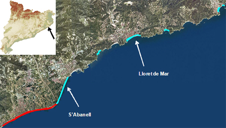
in this project by s’Abanell and Lloret de Mar beaches.
s’Abanell is a 2.5 km long sandy semi-enclosed beach
located in Blanes. The North part of the beach is based
on sa Palomera, a small rocky headland whereas its South
end is open being supported by the Tordera delta. The beach
can be zoned into two areas in function of its urban development
of the hinterland: (i) a N urban area, about 1.5 km long,
with a promenade running along the back of the beach and
(ii) a S semi-urban area, about 1 km long, where the hinterland
is occupied by camping areas with the southernmost 500 m
without any infrastructure in the backbeach. This spatial
variation in the hinterland is also reflected in the degree
of beach use, with the N area being intensively used whereas
the S one presents a much lower density of use. The subaerial
beach has a 32 m average width and it is composed by a sediment
size of about 1.2 mm. Lloret de Mar is a 1.3 km long and
50 m wide sandy bay beach embedded between two low cliffs.
The shoreline is almost linear with the exception of the
areas in the surrounding of the two ends where it adopts
a curved form due to the effects of wave diffraction at
the cliffs. The beach is backed by a promenade placed at
approximately 4.5 m above the sea level which is protected
at the ends by a revetment of quarry stones. A total of
6 short groins, of about 30 m long, are placed along the
beach at regular distances and are partially or totally
covered during “typical” conditions. The emerged
area is characterized by a sediment size of 0.95 mm.
Beach processes
S’Abanell beach
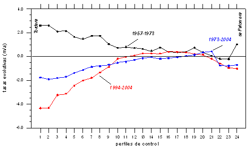
s’Abanell beach presents two different evolutive periods
from 1957 until present: (i) an original accretive behavior
during the period 1957- 1973 and (ii) an actual erosive
one since the end of 70s until present. During the first
period the beach was accreting due to the supplies of the
Tordera river. Although most of sediments were transported
towards the South by the net longshore sediment transport
pattern, part of the sediment was redistributed towards
the beach by diffusion and by the action of secondary southern
waves. At the end of this period the beach reached its maximum
width. During the second period, the beach presented an
erosive behavior that can be related to the sharp decrease
in river sediment supplies due to the dredging of several
millions of m3 of sediment from the river bed mainly from
the end of the 60s to the end of the 70s. This affected
the balance between sediment sources and removal due to
littoral dynamics and it determined the Tordera delta to
be reshaped and eroded. Since the delta front was acting
as a dynamical support for the beach (at its S end), the
beach started to be eroded. The beach shows two differentiated
parts in terms of shoreline evolution: (i) a N part where
the beach is almost stable and, (ii) a S one extending along
1 km, where the beach is erosive with shoreline recession
rates increasing towards the S. The average annual sediment
loss in the beach has been calculated to be 30,000 m3/yr
which should be removed from the coastal cell (the beach)
by the southwards directed net longshore sediment transport.
Lloret de Mar
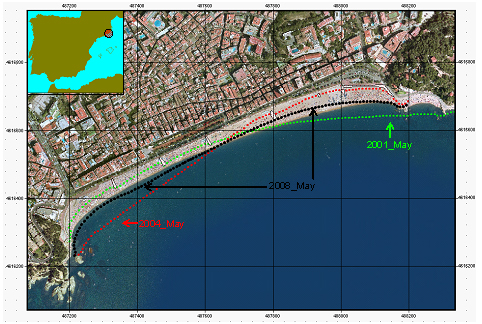
Lloret de Mar is a pocket beach with two headlands delimiting
a closed sediment cell. Due to this, shoreline changes are
limited to coastline fluctuations around an equilibrium
shape depending on the direction of the incoming waves.
The most frequent configuration corresponds to a shoreline
orientated towards the SSE which corresponds to the direction
of the integrated energy flux of effective waves in the
area and it will correspond to the equilibrium shape. The
other two configurations correspond to: (i) a situation
generated by the cumulative action of Eastern storms during
a long time without the action of secondary S waves resulting
in an extreme reorientation towards the South (e.g. May
2004) and; (ii) a situation generated by the cumulative
action of Southern storms without the action of E waves
resulting in an extreme reorientation towards the North
(e.g. May 2001). It has to be noted that this last configuration
is not very frequent in the area due to the dominance of
E waves. An analysis of beach shoreline changes from 1986
until present has demonstrated that sediment losses from
the beach are negligible and, in consequence, it can be
considered as a closed sediment cell.
Beach problems
Different problems related to beach malfunction regarding
the protection of the hinterland have been detected in both
beaches. These problems vary in intensity depending on the
balance between storm characteristics and beach morphology
at the time of the storm impact. Minor problems occur when
the beaches are overtopped by waves during the storm and
the promenade and the area behind the beach is overwashed
by water and sediment removed from the beach. These events
usually occur when total water level during the storm exceeds
the beach crest level and promenade height.
When waves impact directly on the promenade,
failure of the infrastructure usually occurs. In most of
the cases, the failure is due to the fact that most of the
existing beach promenades along the Spanish Mediterranean
coast were built in the 70s during the tourist boom. At
that time, beaches were wide and promenades were not generally
built taking into account that waves could impact on the
structure. As a consequence they were not designed as coastal
structures but as architectural elements. As erosion becomes
dominant in our coasts, beaches protecting these infrastructures
get progressively narrower and storm waves were able to
directly impact on them. If other infrastructures are present
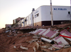
in the beach, they will be also affected. An example in
the s’Abanell beach are the existing facilities of
a desalinization plant (wells and a pumping station). Because
these facilities were built in the most erosive stretch,
few years after their construction were severely affected
by storm impacts.
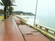
|
|
|
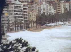
Protection problems in s’Abanell
beach |
In the case of pocket beaches without background erosion,
this problem can also be present although the average beach
width exceeds the storm-induced erosion. This will occur
when the storm impacts on a beach showing an extreme reorientation.
Under these conditions, although the beach has the same
subaerial surface, this is “badly distributed”
because there will be a part of the beach very wide and
another part very narrow.
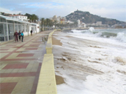
|
|
|
Protection problems in Lloret
de Mar beach |
Application of the Frame of Reference approach
The Frame of reference approach provides a systematic framework
for the development and implementation of a policy for coastal
management. The application of the Frame of Reference to
Costa Brava beaches is illustrated in the figure below.
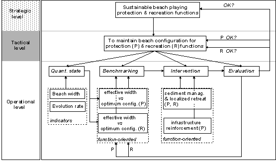
Application of the Frame-of-Reference for
protection (P) and recreation (R) oriented beach management.
The strategic objective is the Sustainable
erosion management in Costa Brava beaches. This
has to be done in such a way that the beach has to properly
play both targeted functions: protection
during winter and recreation during
summer.
To achieve this objective we can make use of the concept
of favourable sediment status, that due to the characteristics
of these beaches will be time-dependent:
- winter (stormy period) – Protecting infrastructures:
Volume of sediment required to generate a beach wider
than the one to be eroded by storms (Tr to be selected
).
- summer (calm period) – Recreational carrying
capacity: Volume of sediment required to generate
a beach wide enough to accommodate users (~ 30 m ).
Present erosion management in s’Abanell
At present, erosion management in s’Abanell beach
is reactive. Thus, actions limit to:
- promenade reinforcement
- emergency beach nourishments [170,000 m3 (11/07) +
165,000 m3 (05/08) + 250,000 m3 (07/09)]
- relocation of camp site limits – retreat –
- desalinization plant protection
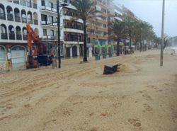
Emergency beach nourishment at South s’Abanell
beach at December 2007.
|