|
A setback line is normally defined as the landward limit of a buffer zone along the coastline where building restrictions or prohibitions are applied. The width of this buffer will depend on the associated physical, environmental and socioeconomic criteria.
1. The use of setback lines
The use of setback lines is basically a trade off between coastal development on the one hand and prevention of an unacceptable risk due to coastal erosion on the other. Many investors are either unaware of the risk, or do not think they are liable for any possible damage. Often only the commercial potential is included in the investment decision to build close to the sea while the risk is entirely disregarded [16]. Regional and national governments should however maintain a broader perspective of the issue, including the long term risks and the need for coastal resilience. This requires an assessment of the risk from coastal erosion as well as a procedure how to incorporate this risk into an economic costbenefit analysis. Furthermore, also ecological values and social motives, such as public access to the beach, can be included in the rationale for defining set back lines.
A preliminary analysis of the legal instruments and policies of the EU and of individual Member States show the lack of a common methodology for setback lines at the European level. However, the Protocol on ICZM of the Barcelona Convention is one example of where there is a clear reference to setback lines (see box). The development of a common method for setback lines should be considered by the Commission as a part of the European cohesion policy and as an initiative which could foster the implementation of the Mediterranean ICZM Protocol in Member States that are Contracting parties to that Convention (Spain, France, Italy, Slovenia, Greece, Malta, Cyprus).
This common method should be based on scientific knowledge of natural processes, information on ecological and landscape values and an analysis of the costs of implementation under local circumstances. This information should be combined with the perceptions and views of stakeholders at the local level in a process of open communication and discussion. The outcome of this participatory process should be used to make a final decision on a setback line that is scientific valid, socioeconomically defendable and broadly acceptable to the public. Appropriate pilots sites along the European coast could be used to test the methodology.
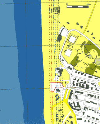
Example of risk lines for a coastal town |
Article 8 of the Mediterranean Protocol on Integrated Coastal Zone Management states:
‘[…] the Parties:
(a) Shall establish in coastal zones, as from the highest winter waterline, a zone where construction is not allowed. Taking into account, inter alia, the areas directly and negatively affected by climate change and natural risks, this zone may not be less than 100 meters in width, subject to the provisions of subparagraph
(b) below. Stricter national measures determining this width shall continue to apply.
(b) May adapt, in a manner consistent with the objectives and principles of this Protocol, the provisions mentioned above:
- for projects of public interest;
- in areas having particular geographical or other local constraints, especially related to population density or social needs, where individual housing, urbanisation or development are provided for by national legal instruments.
[…]’ |
|
|