From the preceding chapters it is clear that a sustainable solution to coastal erosion problems should be based on an understanding of the sediment dynamics, framed in a policy context with explicit objectives and an institutional environment in which each stakeholder has a clear role. The CONSCIENCE project introduces the Frame of Reference [13] as an aid to formulate this policy. Through this Frame a transparent erosion management policy becomes possible. Also the different Eurosion concepts can be given a suitable place in management.
1.The Frame of Reference for policy formulation
Characteristics of the Frame of Reference are the definition of clear objectives at strategic and tactical levels and an operational decision recipe involving four steps. At the highest (policy) level a strategic objective is formulated, determined by the long term vision about desired development of the coast. This vision could be based on generic ideas about sustainable development and should ideally reflect the interdependency of the natural coastal and socioeconomic systems.
At the next level one or more objectives are formulated describing in more detail what has to be carried out in order to achieve the strategic objective.
As this implies a choice between different tactics, we call these the tactical objective(s). If, for instance, at a strategic level the objective formulated is 'sustainable development of coastal values and functions', then at the tactical level we have to choose between different options, such as maintaining the coastline at its current position (i.e. not allowing erosion), or allowing a certain variability in coastline position.
Once this tactical objective has been defined, the actual management process regarding interventions can be formulated through four steps, namely:
- Quantitative state concept: a means of quantifying the problem at hand. Coastal state indicators (CSIs) (i.e. specific parameters that play a role in decision making) are relevant at this stage of the process.
- Benchmarking process: a means of assessing whether or not action is required. CSIs are compared to a threshold value at this stage.
- Intervention procedure: a detailed definition of what action is required if the benchmark values are exceeded.
- Evaluation procedure: Impact assessment of the action taken. If the action was not successful it may be necessary to revise the strategic/tactical objectives (hence the feedback loops in the figure below).
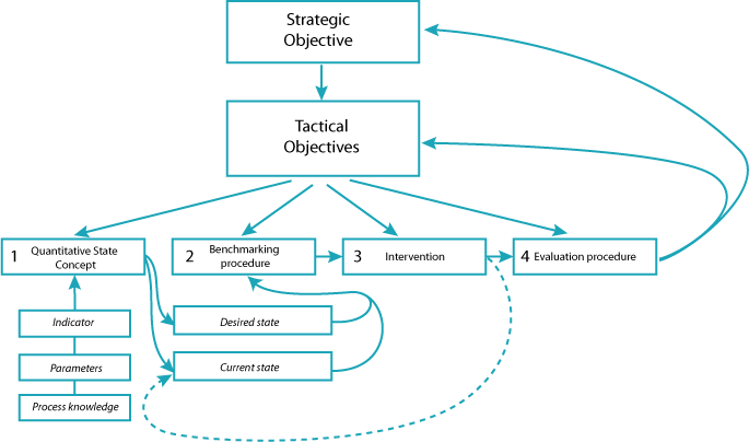
Generic Frame of Reference for coastal management
Having formulated the strategic and tactical objectives, the operational management is largely a matter for coastal practitioners and experts. In the benchmarking procedure the current state of the coast is compared with the desired state, after which the need for intervention is determined. The procedure describes the kind of information that is needed and how it is collected. Ideally a monitoring programme is in place which enables a pro-active response. Simulation models can be used to predict future coastal behaviour based on historic data.
In order to follow these operational steps, it is evident that we first need tactical and strategic objectives. These cannot be derived by scientists and practitioners alone, since this requires political decisions about the desired development of the coast and how much effort (time and money) society is willing to spend on reaching or maintaining this desired development.
2. Setting objectives
At the strategic level we have to answer questions regarding the values and functions of our coast. For instance, many coasts contain valuable ecosystems, sometimes explicitly protected through national or European legislation (e.g. Natura 2000). At the same time these coasts are used for recreation, housing, groundwater extraction, agriculture etc. Where the hinterland is low lying, the coast also has a protection function against flooding from sea. Coastal erosion can threaten one or more of these values and functions. Before deciding to act to control erosion, it is advisable first to analyse the relationship between coastal dynamics and the functions of the coast. For instance, a dynamic and sometimes eroding coastline is less of a problem in the absence of built-up areas. Seasonal beach erosion may not be a problem for recreation, if it only happens during the winter storms. In other instances, it may be essential not to tolerate any coastal erosion in case this would lead to significant coastal flooding of built-up areas.
In practice, it appears very difficult to set realistic and unambiguous objectives for coastal erosion management. This already became apparent from the analysis of 60 case studies done by the EUROSION project, which concluded that very few case studies had clearly defined their objectives for coastal erosion management [1]. Developing strategic and tactical objectives should be part of a broader ICZM policy. Using the principles of ICZM is the best way to guarantee a sustainable development policy for coastal erosion, which has the support of all relevant stakeholders.
At the strategic level, objectives are often linked to key policy principles, such as safety and sustainable development. But from a strategic objective it does not directly become clear how to deal with coastal erosion. Therefore, a tactical objective is needed to determine if coastal erosion needs to be controlled or not.
For instance, in the UK, the Department for the Environment, Food and Rural Affairs (Defra) has defined the following possible tactical objectives for coastal erosion management [14]:
- Hold the line: maintain or upgrade the level of protection provided by defences;
- Advance the line: build new defences seaward of the existing defence line;
- Managed realignment: allowing retreat of the shoreline, with management to control or limit movement;
- No active intervention: a decision not to invest in providing or maintaining defences.
The table below shows the different strategic and tactical objectives found in the 6 CONSCIENCE pilot sites. Note that in some cases these objectives were not officially laid down in policy documents.
Strategic and tactical objectives for the CONSCIENCE pilot sites
3. Temporal and spatial scales for objectives
It is important to realise that objectives can be made for different time horizons. For instance, providing safety against erosion and flooding due to a storm has a typical time horizon of days: the coast should be strong enough to withstand a storm on any day of the year (and especially during the stormy season). On the other side of the spectrum we may find a time horizon of decades to centuries. For instance if we would like to manage coastal erosion in view of sea level rise and climate change. For each of these temporal scales there is an associated spatial scale: for every day safety we need to zoom in to the condition of the coast up to metres or hundreds of metres. For adaptation to sea level rise we define the coastal cell at the scale of tens to hundreds of kilometres. By way of example take a look at the three different scales for management of the Dutch coast.
4. How do the EUROSION concepts fit in?
In many instances, enhancing coastal resilience is an appropriate means to promote sustainability. It should therefore be used as a guiding principle when formulating objectives for coastal management. Good examples of resilient objectives are ‘managed realignment’ and ‘do nothing’. But even an objective such as ‘hold the line’ could allow for some resilience, for instance by using nourishment to replace losses and maintain a healthy beach. It is often not necessary to demand that at any point in time and place the coastline should be at a pre-defined position. Allowing some flexibility in this criterion would enable the coastline to fluctuate around an average position, which is much more efficient. For example, the Dutch definition of the ‘coastline’ is related to a volume of sand around the mean low water line. This definition allows redistribution of sediment close to the coastline without changing the formal coastline position.
The concepts of coastal sediment cell, strategic sediment reservoir and favourable sediment status are useful for implementation of erosion management at the operational level:
- The coastal sediment cell is the most logical unit to express the sediment situation. Therefore, the coastal cells concept is used in definitions of the quantitative state of the coast.
- Favourable sediment status is an expression of the desired state of our coast and should be used for the benchmarking procedure.
- The strategic sediment reservoir is an essential component of the quantitative state of the coast, and can be used as a sediment supply for nourishments as an intervention measure.
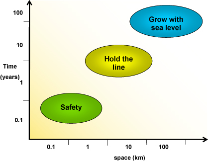
A graphical representation of objectives in time and space
|