Make your problem and objectives
Measurable: You should be able
to measure the extend of the problem and whether you are meeting
the objectives or not
Achievable - Are the objectives
you set, achievable and attainable?
Realistic – Can you realistically
achieve the objectives with the resources you have?
Time – When do you want
to achieve the set objectives? |
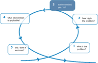
Once an erosion problem has been specified (step
1) and quantified (step
2) in terms of one or more indicators, a
clear decision recipe may help in deciding whether action is needed
or not. First part of this recipe is a benchmarking procedure,
answering several questions:
1. What is the actual state of the indicator ?
Monitoring
Monitoring
of beaches and the near shore zone provides important information
about the state of the coastal system, more in particular about
the actual state of the indicators of our interest. It represents
input into the statistical descriptors and numerical models.
Key points for any monitoring program include:
- Establish what the data is to be used for. Select specific
indicators.
A wide range of data could be used in coastal management, including
data on winds, waves, tides, beach sediment, offshore bathymetry,
coastal profiles, geomorphologic features, coastal defences,
beach nourishment or recycling. All will cost money to collect
and that cost should be justified;
- Establish a reliable system of ground control points or permanent
markers that are used by all surveying groups, whatever technique
they are using;
- Explicitly state the datum system to be used;
- Establish a clear set of guidelines for the surveys, including
tolerances and National or International Standards to be met
(such as ISO or British Standards) and guidance on when to survey
(with respect to the months, the spring-neap tidal cycle and
the occurrence of storms).
An assessment of data needs for specific coastal state indicators
is given in CONSCIENCE report D10.; an
overview of innovative monitoring methods in CONSCIENCE
report D15 and an update of available models in CONSCIENCE
report 13b and 13c
2. Desired state or threshold value
The definition of a desired state or threshold value of an indicator,
is necessary to enable a clear signal for action: whenever the
actual state of an indicator shows a negative difference from
the desired state, action is due.
Examples of different thresholds and benchmarking procedures may
be found e.g. in CONSCIENCE report
D8, and in the pilot site reports Holland,
Pevensey,
Costa
Brava
Favourable sediment status
Basically, the thresholds for different indicators all relate
to a favourable sediment status (key
concept of shore line erosion mangement) of a specific sub-cell
of the coastal system. A fine example of which is provided by
the pilot site Holland.
3. Achievable and attainable ?
Time scale
Do we have time to react, or is immediate action the only option
? The time scale (see step
2) involved, is an important aspect considering achievability
of the objective to maintain a certain desired state of an indicator.
Strategic sediment reservoir
Do we have the resources to tackle the problem ? According to
the EUROSION
recommendations, advocating sediment management as a key to coastal
erosion management, one of the key
concepts is a strategic sediment reservoir:
supplies of sediment of ‘appropriate’ characteristics
that are available for replenishment of the coastal zone, either
temporarily (to compensate for losses due to extreme storms)
or in the long term (at least 100 years). They can be identified
offshore, in the coastal zone (both above and below low water)
and in the hinterland.
The definition of strategic sediment reservoirs must guarantee
sediment resources.
Financial resources
Besides the physical resources, financial resoources are crucial
to achieve the objectives.
4. Who is concerned ? Who is responsible ?
Decision proces
The choice for an achievable desired state (or acceptable threshold
value), typically is a political one. It is closely linked to
the availability of resources and to the question who has access
to it.
As illustrated for example by the various CONSCIENCE pilot
sites and by CONSCIENCE report D8,
responsibilities and decision making processes on coastal erosion
management, show large differences across Europe. A clear analysis
of this process at a particular site is necessary to attain an
implementable strategy.
|