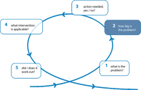
In order to assess the significance and magnitude of
the coastal erosion problem it is necessary to develop some quantitatve
measure, expressing the effect of the physical erosion process
on a specific coastal function.
1. Coastal State Indicators
A quantitatve measure, expressing the effect of the physical
erosion process on a specific coastal function is called a Coastal
State Indicator (CSI).
A very simple indicator is for instance beach width: a wide beach
is good for recreation, whereas coastal erosion could lead to
a very small beach that cannot be used. A list of CSI’s
can be found in the CONSCIENCE report D9 on Indicators.
CSI's major functions are:
- to assess the condition of the environment
- to monitor trends in conditions over time
- to compare across situations
- to provide an early warning signal of changes in the environment
- to diagnose the cause of an environmental problem
- to anticipate future conditions and trends
Some currently utilized indicators
(CSI’s) for coastal erosion include:
CSI |
Quantity
represented |
Pilot
Site |
Dune strength |
Standard of protection
(SoP) for storm |
Dutch
coast |
Barrier width |
Standard of protection
for storm |
Pevensey
|
Total barrier volume |
Standard of protection
for storm |
Pevensey |
Backshore width |
Standard of protection
for storm |
Black
Sea |
Dune zone width |
Standard of protection
for storm |
Black
Sea |
Dune zone height |
Standard of protection
for storm |
Black
Sea |
Momentary coastline |
Position & boundary
condition for SoP |
Dutch
coast |
Beach width |
Boundary condition for
SoP of hard defence |
Costa
Brava |
Barrier crest position |
Position |
Pevensey |
Shoreline position |
Position |
Black
Sea |
Shoreline position |
Position |
Hel
Peninsula |
Coastline position |
Perception of safety
|
Inch
Beach |
Coastal foundation |
Growth with sea level
rise |
Dutch
coast |
Shoreface volume |
Flood and coastal erosion
risk |
Hel
Peninsula |
Coastal slope |
Flood and coastal erosion
risk |
Black
Sea |
2. Scale of the problem
Although useful as it may seem, an indicator has a limited value
if no temporal aspects are included.
For instance, many beaches in winter are smaller than in summer
period, because of the winter storms. Since most tourists visit
the beach during summer, the small beach in winter may not be
a significant problem. Hence, we have to take into account the
coastal dynamics in our coastal state indicator at various scales:
seasons, years, decades and (especially related to climate change
effects) centuries.
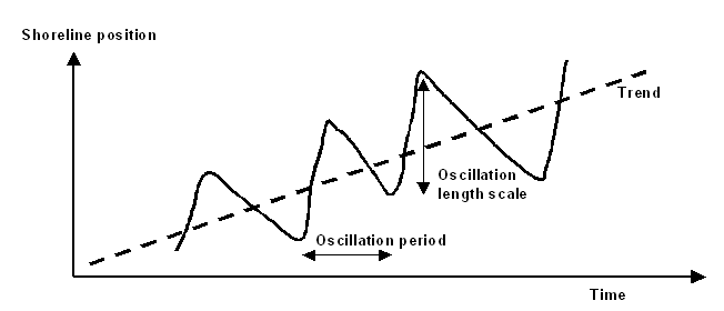
Figure 1: shoreline position as a function
of time: a typical example of cyclic (Seasonal) erosion superimposed
on a long term trend of accretion.
3. WHO is concerned ? WHO is responsible
?
Describing the scale of the erosion problem in physical terms,
it is advisable to consult all stakeholders: it could well be
that the stakeholder’s perception of problem scale differs
from the one which is used in the physical description.
Communication of the different time- and space scales involved
may be necessary (e.g. Holland
Coast).
|